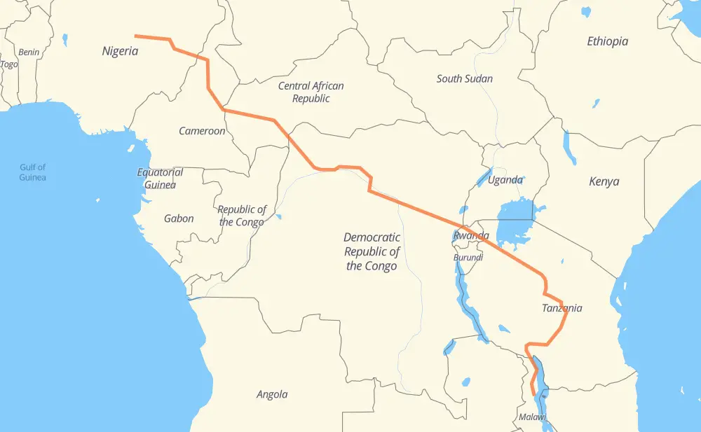
Distance between Zuku and Kachere
The distance from Zuku to Kachere is 3,660 miles by road. Road takes approximately 74 hours and 44 minutes and goes through Bauchi, Lafia, Yola, Garoua, Lagdo, Ngaoundéré and Baoro.
| Shortest distance by air | 2,324 mi ✈️ |
| Car route length | 3,659.9 mi 🚗 |
| Driving time | 74 h 44 min |
| Fuel amount | 124.5 gal |
| Fuel cost | 489.2 USD |
| Point | Distance | Time | Fuel | |
| Wundi | 0 mi | 00 min | 0.0 gal | |
|
A3 94 mi, 1 h 54 min
|
||||
| Bauchi | 94 mi | 1 h 54 min | 3.2 gal | |
|
A345 178 mi, 3 h 31 min
|
||||
| Lafia | 273 mi | 5 h 26 min | 9.1 gal | |
|
A345 61 mi, 1 h 10 min
|
||||
| Yola | 334 mi | 6 h 37 min | 11.2 gal | |
|
F.252 D17 126 mi, 2 h 45 min
|
||||
| Lagdo | 459 mi | 9 h 23 min | 15.4 gal | |
|
N1 117 mi, 2 h 21 min
|
||||
| Ngaoundéré | 577 mi | 11 h 44 min | 19.5 gal | |
|
N1 286 mi, 5 h 44 min
|
||||
| Baoro | 864 mi | 17 h 28 min | 29.2 gal | |
|
RN 3 229 mi, 4 h 34 min
|
||||
| Bangui | 1,093 mi | 22 h 03 min | 37.0 gal | |
|
RN 2 RN6 168 mi, 3 h 22 min
|
||||
| Gemena | 1,261 mi | 25 h 25 min | 42.5 gal | |
|
RN6 745 mi, 15 h 38 min
|
||||
| Lubutu | 2,006 mi | 41 h 03 min | 67.7 gal | |
|
RN3 RP529 267 mi, 5 h 18 min
|
||||
| Gisenyi | 2,273 mi | 46 h 22 min | 77.1 gal | |
|
NR2 29 mi, 34 min
|
||||
| Musanze | 2,302 mi | 46 h 57 min | 78.0 gal | |
|
NR2 T3 701 mi, 13 h 56 min
|
||||
| Dodoma | 3,002 mi | 60 h 53 min | 101.8 gal | |
|
T3 T5 192 mi, 4 h 14 min
|
||||
| Iringa | 3,194 mi | 65 h 08 min | 107.4 gal | |
|
T1 M1 411 mi, 8 h 24 min
|
||||
| Mzuzu | 3,606 mi | 73 h 33 min | 122.3 gal | |
|
M5 60 mi, 1 h 10 min
|
||||
| Kachere | 3,666 mi | 74 h 44 min | 124.6 gal | |
Hotels of Kachere
Frequently Asked Questions
How much does it cost to drive from Zuku to Kachere?
Fuel cost: 489.2 USD
This fuel cost is calculated as: (Route length 3,659.9 mi) / (Fuel consumption 29.4 mpg) * (Fuel price 3.93 USD / gal)
You can adjust fuel consumption and fuel price here.
How long is a car ride from Zuku to Kachere?
Driving time: 74 h 44 min
This time is calculated for driving at the maximum permitted speed, taking into account traffic rules restrictions.
- 737 mi with a maximum speed 56 mph = 13 h 9 min
- 2,759 mi with a maximum speed 50 mph = 55 h 29 min
- 155 mi with a maximum speed 31 mph = 4 h 59 min
- 2 mi with a maximum speed 25 mph = 5 min
- 12 mi with a maximum speed 12 mph = 59 min
The calculated driving time does not take into account intermediate stops and traffic jams.
How far is Zuku to Kachere by land?
The distance between Zuku and Kachere is 3,659.9 mi by road.
Precise satellite coordinates of highways were used for this calculation. The start and finish points are the centers of Zuku and Kachere respectively.
How far is Zuku to Kachere by plane?
The shortest distance (air line, as the crow flies) between Zuku and Kachere is 2,323.9 mi.
This distance is calculated using the Haversine formula as a great-circle distance between two points on the surface of a sphere. The start and finish points are the centers of Zuku and Kachere respectively. Actual distance between airports may be different.
How many hours is Zuku from Kachere by plane?
Boeing 737 airliner needs 4 h 40 min to cover the distance of 2,324 mi at a cruising speed of 497 mph.
Small plane "Cessna 172" needs 17 h to flight this distance at average speed of 136 mph.
This time is approximate and do not take into account takeoff and landing times, airport location and other real world factors.
How long is a helicopter ride from Zuku to Kachere?
Fast helicopter "Eurocopter AS350" or "Hughes OH-6 Cayuse" need 15 h 35 min to cover the distance of 2,324 mi at a cruising speed of 149 mph.
Popular "Robinson R44" needs 17 h 48 min to flight this distance at average speed of 130 mph.
This time is approximate and do not take into account takeoff and landing times, aerodrome location and other real world factors.
What city is halfway between Zuku and Kachere?
The halfway point between Zuku and Kachere is Yakusu. It is located about 2 mi from the exact midpoint by road.
The distance from Yakusu to Zuku is 1,832 mi and driving will take about 37 h 49 min. The road between Yakusu and Kachere has length 1,828 mi and will take approximately 36 h 55 min.
The other cities located close to halfway point:
Where is Zuku in relation to Kachere?
Zuku is located 2,324 mi north-west of Kachere.
Zuku has geographic coordinates: latitude 10.50572, longitude 8.90513.
Kachere has geographic coordinates: latitude -12.00389, longitude 34.04899.
Which highway goes from Zuku to Kachere?
The route from Zuku to Kachere follows T3, RN6, N1, RN3, RN 3, A345, T1, M1, T5, RP529, RP405, NR2, RN 1, RP408, M5, T10, RP401.
Other minor sections pass along the road:
- RN23: 58 mi
- A3: 53 mi
- D17: 42 mi
- T11: 37 mi
- NR5: 37 mi
- RS340: 26 mi
- T8: 24 mi
- F.252-1: 24 mi
- RP 61: 20 mi
- F.252: 17 mi
- A13: 16 mi
- RN2: 16 mi
- RN4: 14 mi
- N 1: 12 mi
- RN 2: 7 mi
- A4: 5 mi
- RN 14: 3 mi
- NR1: 2 mi
- RP61: 1 mi
- RP 63: 1 mi