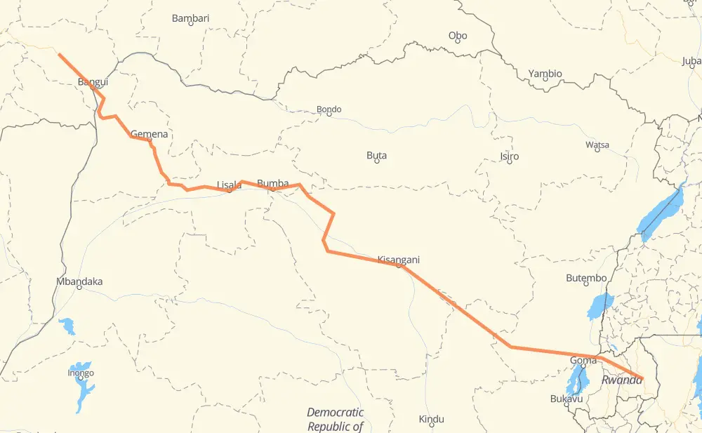
The distance from Boyangéné to Ruramira is 1,392 miles by road. Road takes approximately 28 hours and 55 minutes and goes through Bangui, Gemena, Lubutu, Gisenyi and Musanze.
You can adjust fuel consumption and fuel price here.
How long is a car ride from Boyangéné to Ruramira?
Driving time:
28 h 55 min
This time is calculated for driving at the maximum permitted speed, taking into account traffic rules restrictions.
368 mi with a maximum speed 56 mph = 6 h 34 min
935 mi with a maximum speed 50 mph = 18 h 48 min
64 mi with a maximum speed 31 mph = 2 h 3 min
14 mi with a maximum speed 25 mph = 33 min
11 mi with a maximum speed 12 mph = 54 min
The calculated driving time does not take into account intermediate stops and traffic jams.
How far is Boyangéné to Ruramira by land?
The distance between Boyangéné and Ruramira is 1,392.5 mi by road.
Precise satellite coordinates of highways were used for this calculation. The start and finish points are the centers of Boyangéné and Ruramira respectively.
How far is Boyangéné to Ruramira by plane?
The shortest distance (air line, as the crow flies) between Boyangéné and Ruramira is 1,006 mi.
This distance is calculated using the Haversine formula as a great-circle distance between two points on the surface of a sphere. The start and finish points are the centers of Boyangéné and Ruramira respectively. Actual distance between airports may be different.
How many hours is Boyangéné from Ruramira by plane?
Boeing 737 airliner needs 2 h 1 min to cover the distance of 1,006 mi at a cruising speed of 497 mph.
Small plane "Cessna 172" needs 7 h 21 min to flight this distance at average speed of 136 mph.
This time is approximate and do not take into account takeoff and landing times, airport location and other real world factors.
How long is a helicopter ride from Boyangéné to Ruramira?
Fast helicopter "Eurocopter AS350" or "Hughes OH-6 Cayuse" need 6 h 44 min to cover the distance of 1,006 mi at a cruising speed of 149 mph.
Popular "Robinson R44" needs 7 h 42 min to flight this distance at average speed of 130 mph.
This time is approximate and do not take into account takeoff and landing times, aerodrome location and other real world factors.
What city is halfway between Boyangéné and Ruramira?
The halfway point between Boyangéné and Ruramira is Yata. It is located about 29 mi from the exact midpoint by road.
The distance from Yata to Boyangéné is 667 mi and driving will take about 14 h 28 min. The road between Yata and Ruramira has length 725 mi and will take approximately 14 h 26 min.
The other cities located close to halfway point:
Yanonge is in 790 mi from Boyangéné and 602 mi from Ruramira
Yakapko is in 587 mi from Boyangéné and 805 mi from Ruramira
Yalimbongo is in 578 mi from Boyangéné and 814 mi from Ruramira
Where is Boyangéné in relation to Ruramira?
Boyangéné is located 1,006 mi north-west of Ruramira.
Boyangéné has geographic coordinates: latitude 5.1191, longitude 17.80066.
Ruramira has geographic coordinates: latitude -1.95862, longitude 30.53493.
Which highway goes from Boyangéné to Ruramira?
The route from Boyangéné to Ruramira follows RN6, RN3, RP529, RP405, NR2, RP408, RN 1, RP401.